Mid-rise Living: A New Best Practice?
Vancouver, Canada, intends to fill much of a transit corridor from downtown to the airport with buildings mostly four to 12 stories high.
Philip Langdon, New Urban Network
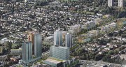
Vancouver, British Columbia, is known for glassy residential towers that rise from podiums containing housing, stores, restaurants, and other pedestrian-scale uses. These tall buildings with broad street-level bases helped the city to more than double its downtown population in the past two decades — to an estimated 105,000.
Now Vancouver is eyeing a different form of development — one that achieves substantial density but in buildings closer to the ground. In May, the City Council approved the Cambie Corridor Plan. Over the next 30 years, it should fill much of the Cambie Street corridor between downtown and Vancouver International Airport with four stories and higher buildings.
Towers will rise at a few of the thoroughfare’s most heavily trafficked locations, but those will be exceptions. For the most part, the Corridor — served by a $2 billion rail line that opened in August 2009 — will top out at the twelfth floor. Vancouver Planning Director Brent Toderian sees the combination of “mid-rise urbanism,” rail transit, and district energy systems as “a new North American’ best practice.'”
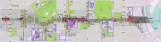
The Canada Line rail service, publicly owned and privately operated, has 16 stations along its 12-mile route and is already heavily used, with 110,000 boardings a day — more than were projected so soon after the start of operations. “The effect on transportation has been transformative,” Toderian says, noting that the line — which runs below ground in most of the city and becomes elevated as it nears the adjoining town of Richmond — did much to help the city handle the surge of activity during the Winter 2010 Olympics.
To take advantage of the investment in transit, the corridor plan authorizes a significant increase in density — this is in a part of the city where most people have been accustomed to bungalows, ranch houses, and other single-family dwellings.
Nearly 14,000 more residents
Key elements of the plan include these:
• By 2041, the 3.7-mile stretch of Cambie from 16th Avenue to the Fraser River will be home to about 35,000 residents — roughly 13,500 more than live there now.
• Many residential buildings will be 6 to 12 stories, achieving a net density (not counting streets and parks) of 110 to 170 units per acre.
• Other buildings, slightly farther from the subway, will be a mix of 4 to 6 stories — high enough to generate a net density of 80 to 130 units an acre.
• Still farther away, but within a 5- to 10-minute walk of the transit stations, the development intensity will decrease to avoid overwhelming the existing neighborhoods. Instead, Toderian envisions these peripheral areas achieving a “gentle density” associated with rowhouses, duplexes, and possibly low-rise apartments.
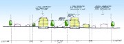
• Rather than letting building heights spike at the stations and then fall off sharply, the objective is relatively consistent heights (and substantial density) along the bulk of Cambie, part of which is a historic boulevard. “We’re talking about 8- to 10- to even 12-stories perimeter block or courtyard buildings at stations, and 6 to 8 stories between stations,” Toderian explained recently in an interview with re: place magazine.
• Towers would be erected at two key stations: Marine Landing near the city’s southern border, where they could rise as high as 36 stories for a density of 130 to 190 units an acre, and Oakbridge Centre, a shopping mall (reported on in this New Urban News article) that will be transformed into a dense mix of retail, employment, housing, and public amenities.
Vancouver’s Vision Evolves
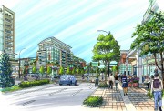
Mid-rise development — in many cases, a few stories of housing over ground-floor retail — has proven popular along thoroughfares in Vancouver in recent years. However, many mid-rise buildings have been just four stories, rather than the anticipated 6-, 8-, 10-, and 12-floor configurations on Cambie Street. In his re: place interview, Toderian said the mid-rise plan devised for Cambie offers Vancouver another way of achieving density, thus reducing the greenhouse-gas emissions associated with dispersed development:
That’s a transition for us because our development industry, and even the marketplace, has come to expect that densification will mean towers with views. I often hear that’s what sells in Vancouver; that’s what the market expects. But, on the other hand, our mid-rise projects do very well in the city. They can be more sustainable. They can even be more affordable and more acceptable to the public, [which] tends to be more antagonistic to height than they are to density. … that helps with our entire discourse on densification in the city.
According to Toderian, a pattern of predominantly 8- to 12-story buildings at the stations and 6 to 8-stories between stations can generate a density comparable to what Vancouver has previously achieved through podiums topped by slim towers.
The city chose mid-rise as the primary form for its Olympic Village development a few years ago, but “this is the first time it has been so explicitly deployed over such a vast area,” says Patrick Condon, a professor at the University of British Columbia and author of the 2010 book Seven Rules for Sustainable Communities.
Condon generally approves of the Cambie framework. He sees it as similar to the development traditionally associated with streetcar lines — a pattern with “an inherently fine grain, with small-footprint buildings competing from frontage on the arterials.”
“While full-block buildings are possible in this form … it is much more typical for buildings to occupy a half, a quarter, or even less of the block face,” Condon points out. “The smaller scale has the advantage of resiliency over time and allows smaller developers and more architects to participate in the city’s construction.”
Condon regrets that officials built a subway rather than a ground-level light-rail line. Surface rail had been twice approved by the TransLink transportation agency “before being overruled by the province,” he notes. The trouble with a subway is that stations are set farther apart than the stops of a typical trolley or light-rail line. Condon says that as a result, walking distances to some Canada Line stations are more than 10 minutes — negating the” organic” nature of the Corridor. “It is impossible to ‘hop on and hop off’ or always within a five-minute walk of transit under these conditions.”
Distances between stations may make it harder to achieve the consistency of development laid out in the plan. Those sections may become less lively and fully built up with fewer pedestrians in the in-between areas. However, there have been calls for adding two more stations to offset some of the inconvenience.
How much density to allow along Cambie was a contentious issue. Though Condon and some others would have preferred even more density, the plan is probably as intense as was politically palatable in light of opposition to density from many of the neighbors.
“The density is higher than you could have gotten approved in any other jurisdiction in North America,”
Condon emphasizes. And, he believes, the mid-rise plan could become “a prototype for the other arterials in the city, arterials which won’t have subway but will, hopefully, have electrified trolley and tram service in the not too distant future.”
Energy and affordability
The plan is impressive in its comprehensiveness. It “supports our shared goal of becoming the world’s greenest city by 2020,” architect Peter Busby wrote in a May 3 commentary in The Vancouver Sun.
New developments must connect to “district heating” systems, which generate energy for buildings throughout a neighborhood or city sector. A district system, like the one that heats the Southeast False Creek neighborhood (including the Olympic Village), achieves higher efficiency and emits less pollution than boilers in individual buildings. In addition, clean sources such as geothermal energy are used for some district heating plants.
The plan’s “public benefits strategy” includes:
• An increase in childcare facilities, corresponding to the growth in population brought by new development.” Any existing childcare within the Corridor will be retained or replaced should a site currently housing a childcare center be redeveloped,” the plan stipulates.
• Park and public realm improvements, including new park space close to the Fraser River.
• Expansion or upgrading of community facilities, including a public library.
• Housing for all ages and income groups, including expansion of rental housing. In much of the Corridor, the goal is for 20 percent of the housing to be affordable rentals, though this “will not be achieved in all cases.”
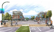
Land use and transportation integration ensure that more than 50 percent of trips will be made by foot, bicycle, and transit by 2020. To make the pedestrian network more convenient and human-scale, pathways and other connections will be installed — connecting to local amenities and breaking down the size of large blocks. In some places, other streets will be built.
Critics have charged that some of the city’s actions are contradictory. For example, the arrival of the subway and taller buildings may push up the price of existing housing — hardly a recipe for affordability. To limit the cost of the subway, stations were kept small — capable of accommodating two-car rather than three-car trains. That has led to complaints of crowding and short-term thinking.
Some have insisted that the city should have done its comprehensive planning before, not after, the rail line construction. Toderian, who arrived in Vancouver after the Canada Line excavation was already underway, says the municipality couldn’t undertake such a complicated planning process earlier.
Even so, many commentators in Canada’s third-largest metropolitan area are impressed. “What makes the plan exceptional is the level of integration it achieves — from the high-level vision and planning principles, right through to the block and building-level design details,” Bob Ransford, a public affairs consultant with new urbanist connections, wrote on May 14 in The Vancouver Sun.
Toderian sees the Cambie plan as progress toward better planning throughout Vancouver: “I think our next step should be to look at transit-oriented planning across the entire city, and corridors and centers planning across the entire city.”
Posted by Drew on June 14, 2011